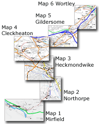
The Leeds New Line route maps
See page 1 for explanation |
|
You are here: Map 2
Northorpe
Dunbottle lane - Walkley lane
|
|
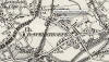
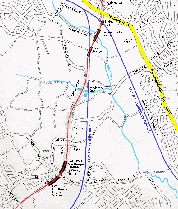 Map 2 Northorpe Map 2 Northorpe
Dunbottle lane to Walkley lane
L.N.W.R Leeds New Line shown in
red
The Lancashire & Yorkshire lines
shown in blue
For the Lancashire & Yorkshire lines shown on this
map -
see Mirfield to Low Moor &
Ravensthorpe branch
|
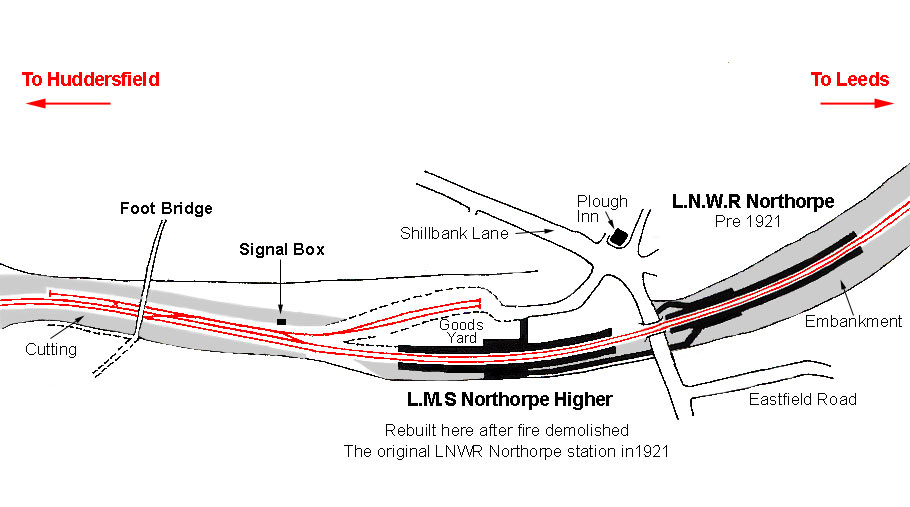
Northorpe
L.N.W.R Northorpe station - Opened 01-10-1900.
Burned down 11-07-1921.
L.M.S Northorpe Higher station - Opened 1921. Closed 05-09 1953. Freight
16-07-1951.
 L.N.W.R
Northorpe 1908 & L.M.S Northorpe Higher 1930 map : David Webdale L.N.W.R
Northorpe 1908 & L.M.S Northorpe Higher 1930 map : David Webdale
Both
old & new stations shown on same map. Built on the North side of Shillbank lane. Timber Platforms & buildings.
Northorpe Higher (L.M.S) opened in 1921 & closed on 5th September 1953
was built to replace the old station at a cost of £15000.
Situated on
the south side of Sillbank lane. Timber construction & small goods yard
with two sidings. Goods yard closed 16th July 1951. |
 The
Leeds New Line part 2: Darren Hosker c/o Paul Holroyd The
Leeds New Line part 2: Darren Hosker c/o Paul Holroyd
Youtube from Darren Hosker
https://www.youtube.com/watch?v=ERNSc1rsxx8 |
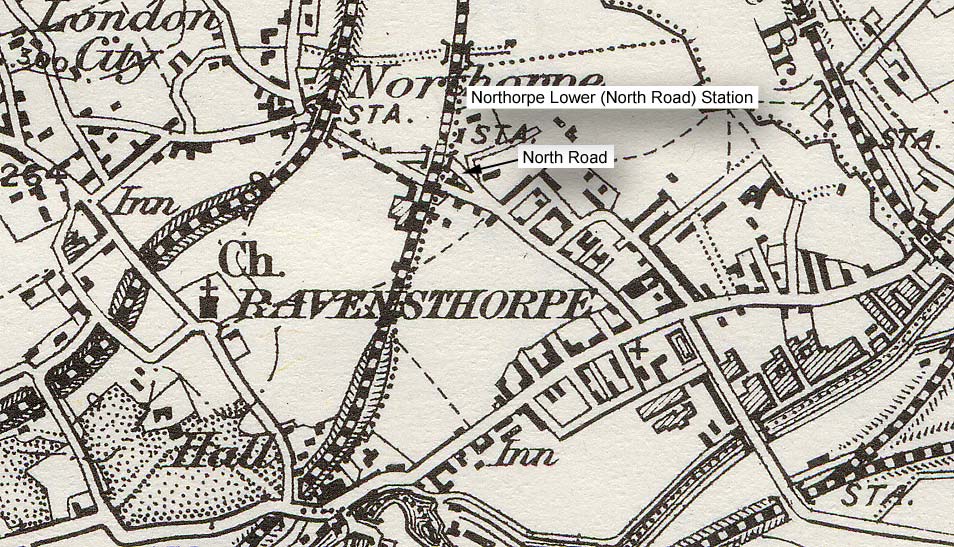
 O
S Map 1902 O
S Map 1902
Both Northorpe LNWR & L&Y stations shown on this map. The L&Y
station labelled Northorpe Lower is on the
Mirfield to Low Moor line |
Fire at Northorpe station
11th July 1921.
A fire was caused by a passing Huddersfield bound freight train at
around 6pm.
The summer of 1921 was one of the hottest, with temperatures
of 86F in the shade.
Shortly after the train had passed a grass fire
started on the embankment on the Leeds side, some distance from the
station.
The fire spread quickly, and soon engulfed the platforms.
Unable to reach the hydrants situated between the platforms, the fire
brigade gave up after half an hour. Firemen concentrated on the row of
houses on Eastfield road, in which windows were broken & woodwork
damaged.
It seemed as though the burning station would fall backwards
onto the houses.
Fortunately the station canopy dragged the burning
buildings forward onto the tracks.
The fire was extinguished at around 10 pm & the damaged rails were replaced by 8am Wednesday. |
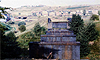
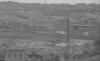
 Station
on Shillbank lane (24-08-14) : Colinne Terry Station
on Shillbank lane (24-08-14) : Colinne Terry
Remains of the bridge where Northorpe upper station was on Shillbank
lane Mirfield. |
/17%20bank%20lane%20west_small.jpg) Bank Lane facing West (14-07-02)
: David Webdale Bank Lane facing West (14-07-02)
: David Webdale
The 1921 Northorpe Higher station built by the L.M.S, after the
original burned down, was up on the left,
now a garden.
Station
entrance is just out of shot down to the left.
An iron bridge spanned the
road here & the pub in the background is the Plough Inn. |
/18%20bank%20lane%20north_small.jpg) Bank lane facing North (14-07-02)
: David Webdale Bank lane facing North (14-07-02)
: David Webdale
At the other side of the road is the site of the
original station.
Entrances were at each side. Eastfield road, just down
to the right (out of shot) had windows broken & woodwork
damaged when fire destroyed the original wooden station buildings in
1921. |
/23%20jill%20lane%20footpath%20bridge_small.jpg) Footpath facing West (14-07-02)
: David Webdale Footpath facing West (14-07-02)
: David Webdale
Found this by accident, hidden by trees, must have used extra blue
bricks for this,
provides footpath access to Northorpe lane through the
railway embankment, (see main map). |
/22%20jill%20lane%20south%20embankment_small.jpg) Jill lane facing South (14-07-02)
: David Webdale Jill lane facing South (14-07-02)
: David Webdale
The embankment, taken from Jill lane facing back towards Northorpe
station. |
/20%20gill%20lane%20west%20bridge_small.jpg) Jill lane facing West (14-07-02)
: David Webdale Jill lane facing West (14-07-02)
: David Webdale
Remnants of the bridge over Jill lane. nice stone, I think it looks like
fireplace.
I assume it carried an iron deck. |
/21%20jill%20lane%20west%20sleepers_small.jpg) Jill lane facing West (14-07-02)
: David Webdale Jill lane facing West (14-07-02)
: David Webdale
On the other side of the road only sleepers remain, used as fence posts. |
%20%20(9%20to%2025%20%2015-09-02)/2%20ponderosa%20north_small.jpg) Ponderosa facing North (08-09-02)
: David Webdale Ponderosa facing North (08-09-02)
: David Webdale
Further North, taken from the track bed on the embankment.
Piles of
bricks dumped here
from demolished houses.
The Ponderosa animal sanctuary is just down on
the right.
|
Park Colliery
Situated between Finching dyke & Lodge lane (to west side of new
line)
Park colliery was accessed via a branch from the L & Y Mirfield line.
The New Line crossed this branch on a 3 arch bridge with a span of 25
feet.
This bridge is long gone now, Park colliery was closed by 1907.
The bridge was demolished & a continuous earth embankment formed in its
place. |
%20%20(9%20to%2025%20%2015-09-02)/3%20l&y%20Mir-%20Heck%20cross%20east_small.jpg) L & Y Mirfield Heckmondwike crossing facing East (08-09-02) : David
Webdale L & Y Mirfield Heckmondwike crossing facing East (08-09-02) : David
Webdale
Maybe I should come back in autumn. Taken from the
L & Y Mirfield branch track bed, now a road leading to the animal sanctuary).
This
brickwork must have looked quite tasty in its day.
Here the line crossed the L & Y branch on a 150
ft lattice girder bridge.
Supported on blue brick & stone pillars, it was built to the same design as
the Battyeford girder bridge. |
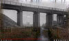
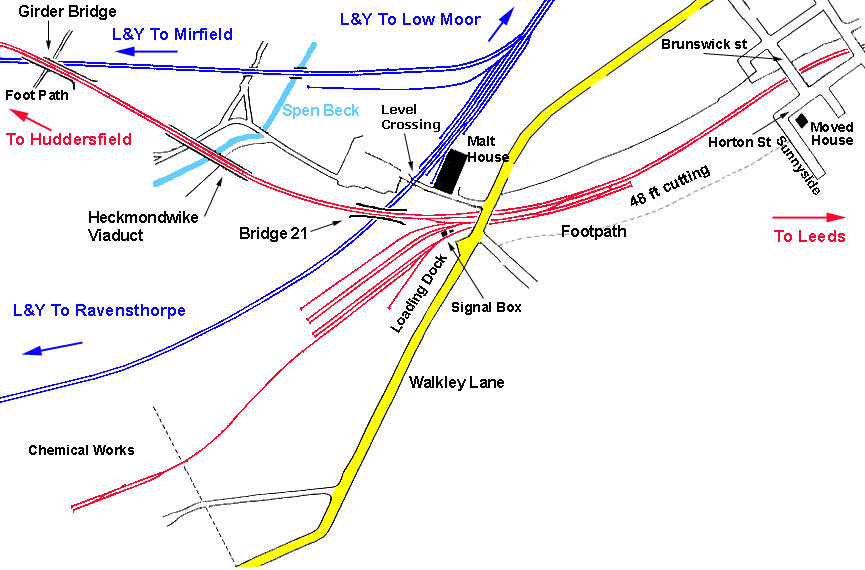
Heckmondwike viaduct
Heckmondwike viaduct South end facing North (08-09-02) : David Webdale
%20%20(9%20to%2025%20%2015-09-02)/5%20heck%20viaduct%20south%20end%20north_small.jpg) This remaining
section of Heckmondwike viaduct stands about 50ft high from the road side,
the photo doesn't do it justice. This remaining
section of Heckmondwike viaduct stands about 50ft high from the road side,
the photo doesn't do it justice.
Taken from Smithes lane, Originally an
80 yards long iron deck supported on brick pillars. This Spanned the valley over Spen Beck.
Originally planned to be 261
yards long, instead an earth embankment & plateau was formed on the
North side of the valley,
using material excavated from the deep
cuttings through Heckmondwike.
This enabled the construction of a
shorter viaduct. |
 Heckmondwike viaduct
Links to Flikr (c1980s) : c/o Player 1 Heckmondwike viaduct
Links to Flikr (c1980s) : c/o Player 1
Photos of steel railway viaduct Heckmondwike links to Flikr |
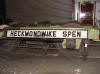
L.M.S Heckmondwike Spen Goods 1930
 L.M.S
Heckmondwike Spen goods map : David Webdale L.M.S
Heckmondwike Spen goods map : David Webdale
Due to the terrain, the goods yard
(opened1st of November 1900),
was situated further south from Heckmondwike station, between Walkley
Lane &
the L & Y Ravensthorpe branch.
(North is to the right on this map).
Note : Nigel Oliver
With support from the L&NWRS, work began in 2013 to new build eight
replica LNWR six-wheel carriages, reinstate a platform plus short
section of Leeds New Line track, and to re-create the former
Heckmondwike Spen signal box.
This is being undertaken by GFB, a social
enterprise
www.greenfuturebuilding.org.uk based in the Malt House. Visitors
welcome, contact Nigel at GFB. |
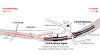
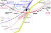
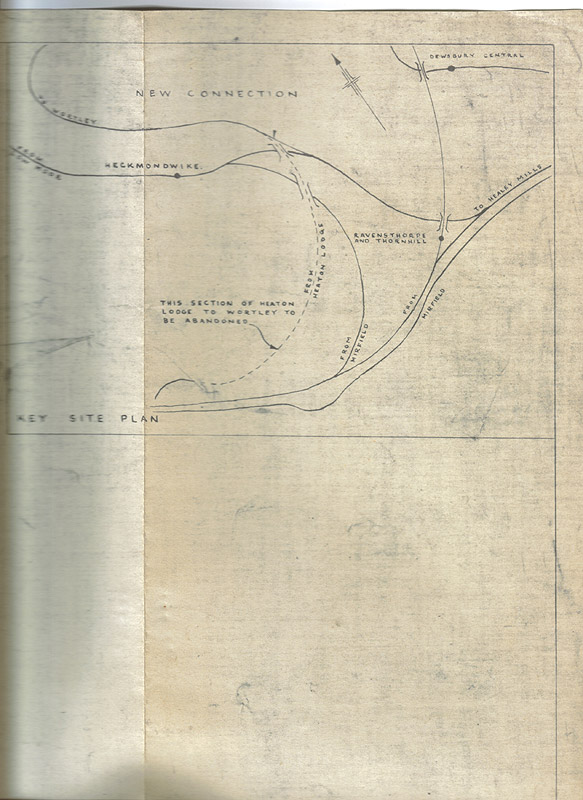
  Plans
for connecting spur L & Y and LNWR (22/12/65) : Paul Holroyd Plans
for connecting spur L & Y and LNWR (22/12/65) : Paul Holroyd
A small part of the plans for building the connecting spur between the L
& Y and LNWR lines at Heckmondwike.
There is a handwritten note saying "Plan enclosed with DE's letter
22/12/65" on my copy. |
B.R Spur Facing south c1987 : K Evans
 In 1966 B.R made this new connection at Heckmondwike Spen Goods yard,
between the L & Y Ravensthorpe branch on right & The Leeds New Line to Liversedge
Spen on left. This was to supply the Charrington Hargreaves oil terminal at the former
Liversedge Spen Goods Yard.
see
page 3
This enabled the closure of the Heaton Lodge
to Liversedge Spen Goods section of line. In 1966 B.R made this new connection at Heckmondwike Spen Goods yard,
between the L & Y Ravensthorpe branch on right & The Leeds New Line to Liversedge
Spen on left. This was to supply the Charrington Hargreaves oil terminal at the former
Liversedge Spen Goods Yard.
see
page 3
This enabled the closure of the Heaton Lodge
to Liversedge Spen Goods section of line. |
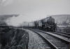
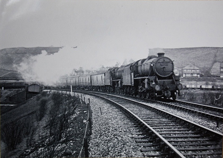
 Class
40 Heckmondwike junction : Bernard Coomber Class
40 Heckmondwike junction : Bernard Coomber
English Electric type 4, now class 40, crossing
bridge 21 & heads for
Leeds at Heckmondwike junction. |
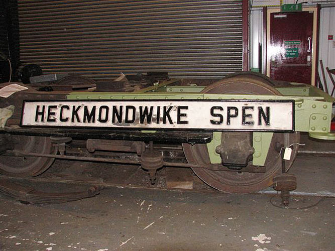
 Heckmondwike
Spen signalbox sign (23-01-07) : Paul Nigel Kirkup
website -
www.vintagecarriagestrust.org Heckmondwike
Spen signalbox sign (23-01-07) : Paul Nigel Kirkup
website -
www.vintagecarriagestrust.org
An original sign from Heckmondwike Spen signalbox rests on a bogie from
Bulleid-designed carriage no. 1469
at the Museum of Rail Travel, Ingrow, prior to being placed on display. |
 Heckmondwike
& bridge 21
(c1911) : Christopher Franz Heckmondwike
& bridge 21
(c1911) : Christopher Franz
Heckmondwike general view the tracks nearest to us
are the L&Y Mirfield
to Low Moor line.
The tracks behind, passing under the iron bridge (Bridge 21), are the
L&Y Ravensthorpe branch.
The Tracks on top of the iron bridge are the Leeds New Line. |
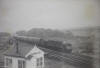
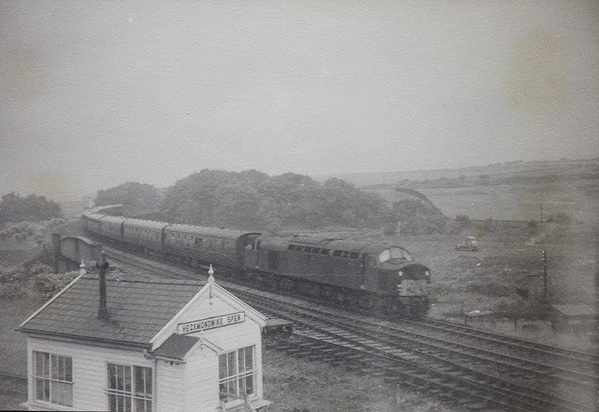
 Black
Fives Heckmondwike junction (02-1963) : Bernard Coomber
collection Black
Fives Heckmondwike junction (02-1963) : Bernard Coomber
collection
Photo taken Feb 1963 showing double headed Black 5's on a Newcastle to
Liverpool express,
leaving Heckmondwike Spen & crossing bridge 21.
The houses behind are on Walkley lane. |
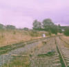
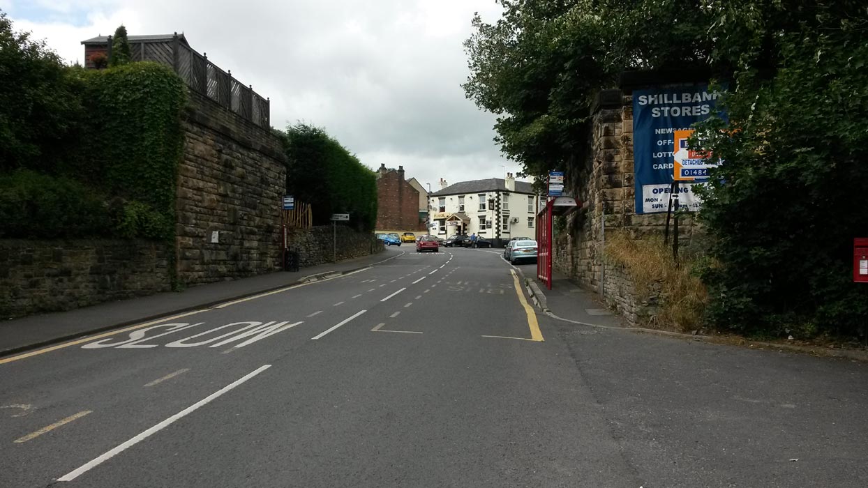
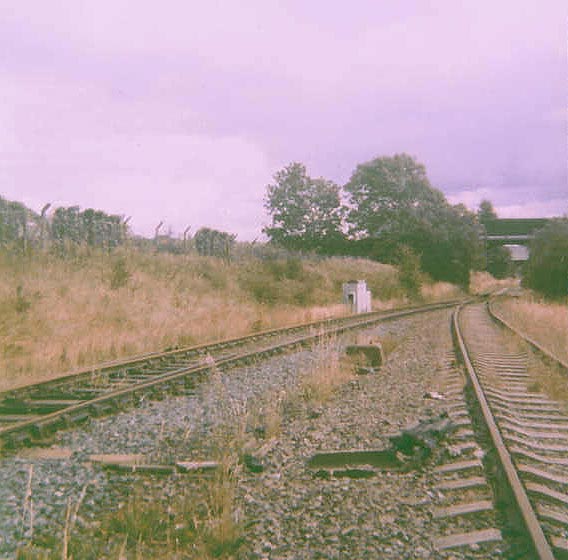
%20%20(9%20to%2025%20%2015-09-02)/8%20walkley%20lane%20bridge%20north_small.jpg) Walkley
facing North (08-09-02) : David Webdale Walkley
facing North (08-09-02) : David Webdale
Next to Heckmondwike Spen Goods found no evidence at all of bridge 21
(originally constructed of stone pillars with an iron deck).
The whole area seems to have been landscaped. Heckmondwike Spen signal
box stood just to the right of the bridge. |
%20%20(9%20to%2025%20%2015-09-02)/25%20walkley%20lane%20bridge%20s%20east_small.jpg) Walkley lane bridge facing South (15-09-02)
: David Webdale Walkley lane bridge facing South (15-09-02)
: David Webdale
Looking back towards Walkley lane bridge from in
the cutting.
Part of the under side of the bridge has been filled in. |
%20%20(9%20to%2025%20%2015-09-02)/7%20walkley%20lane%20north_small.jpg) Walkley
facing North (08-09-02) : David Webdale Walkley
facing North (08-09-02) : David Webdale
The view from Walkley lane, looking towards Heckmondwike. The 48 foot
deep cutting looks reasonably intact.
Excavations from here were used to
create a massive plateau between bridge 21 & Heckmondwike viaduct. |

/17%20bank%20lane%20west.jpg)
/18%20bank%20lane%20north.jpg)
/23%20jill%20lane%20footpath%20bridge.jpg)
/22%20jill%20lane%20south%20embankment.jpg)
/20%20gill%20lane%20west%20bridge.jpg)
/21%20jill%20lane%20west%20sleepers.jpg)
%20%20(9%20to%2025%20%2015-09-02)/2%20ponderosa%20north.jpg)
%20%20(9%20to%2025%20%2015-09-02)/3%20l&y%20Mir-%20Heck%20cross%20east.jpg)
%20%20(9%20to%2025%20%2015-09-02)/5%20heck%20viaduct%20south%20end%20north.jpg)

%20%20(9%20to%2025%20%2015-09-02)/8%20walkley%20lane%20bridge%20north.jpg)
%20%20(9%20to%2025%20%2015-09-02)/25%20walkley%20lane%20bridge%20s%20east.jpg)
%20%20(9%20to%2025%20%2015-09-02)/7%20walkley%20lane%20north.jpg)